

40. Free Download Complete CAD Urban Planning Symbols and Legend Blocks DWG
Advertisements
When working on urban planning projects, especially large-scale planning drawings, having a consistent system of symbols and graphic representation is extremely important. This CAD drawing set is essentially a comprehensive library of planning symbols created to support the preparation, presentation, and management of urban planning maps. At first glance, it is clear that this is not just a collection of random CAD blocks, but rather a well-organized system that includes drawing frames, legend tables, and multiple layers of information related to land use, infrastructure, and urban technical systems.
At the beginning of the drawing set, users can see the layout of the planning drawing frame. The frame follows the common format typically used in planning documentation in Vietnam. Two presentation options are included: one for colored drawings used in presentations or consultation reports, and another for black-and-white drawings typically used in technical documentation. The title block, north arrow, map scale, and annotation areas are placed in familiar positions so readers can easily understand the structure of the drawing.
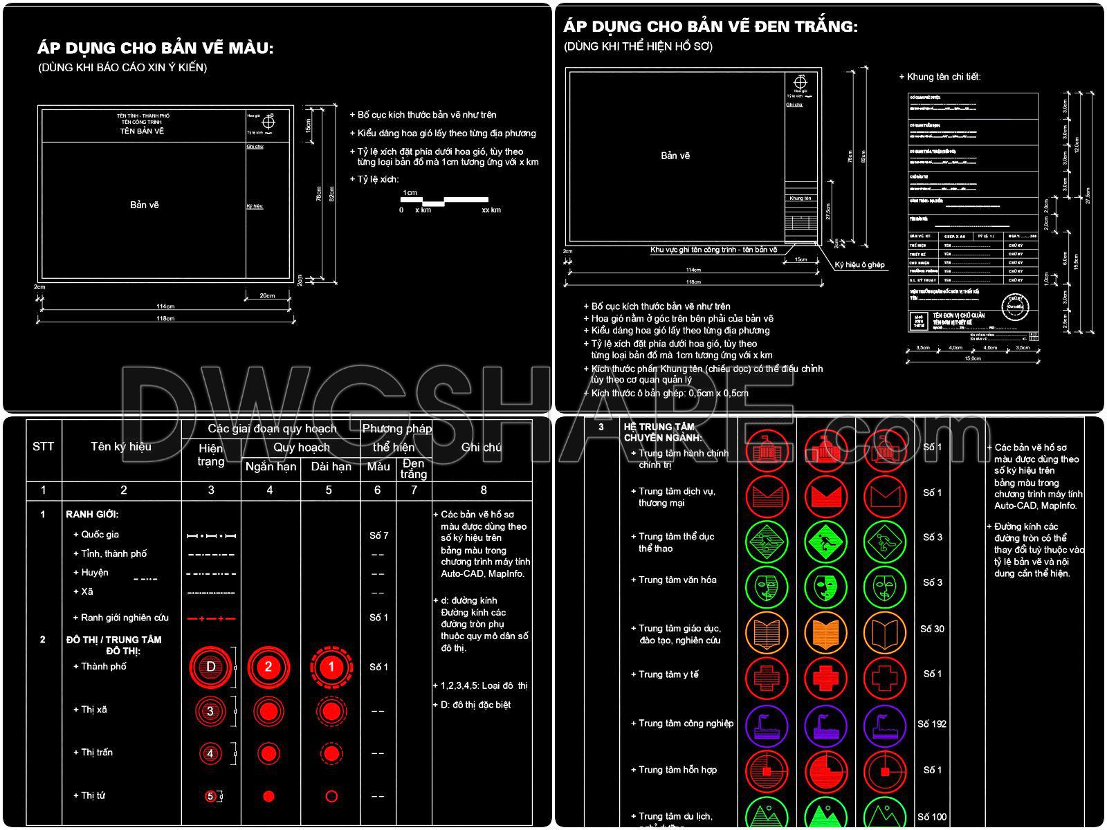
The most important part of this library is the planning symbol legend. This section gathers most of the commonly used symbols in urban planning maps. The symbols are organized into clear categories for easy reference, including administrative boundaries, urban classification, specialized centers, land-use categories, and infrastructure systems.
The boundary symbol group represents administrative levels ranging from national boundaries to provincial, district, and commune levels. Each level is represented by a different line type so readers can quickly distinguish them on the map. The research boundary is also included, which is commonly used to define the planning study area.
Another important section is the classification of urban centers and specialized functional centers. In regional planning or master planning maps, it is necessary to indicate major urban centers, satellite cities, or specialized functional hubs. The symbol set uses circular and geometric icons to represent facilities such as administrative centers, commercial centers, sports complexes, cultural centers, educational institutions, and healthcare centers. The visual representation is intuitive, making it easy to understand the spatial structure of the planning area.
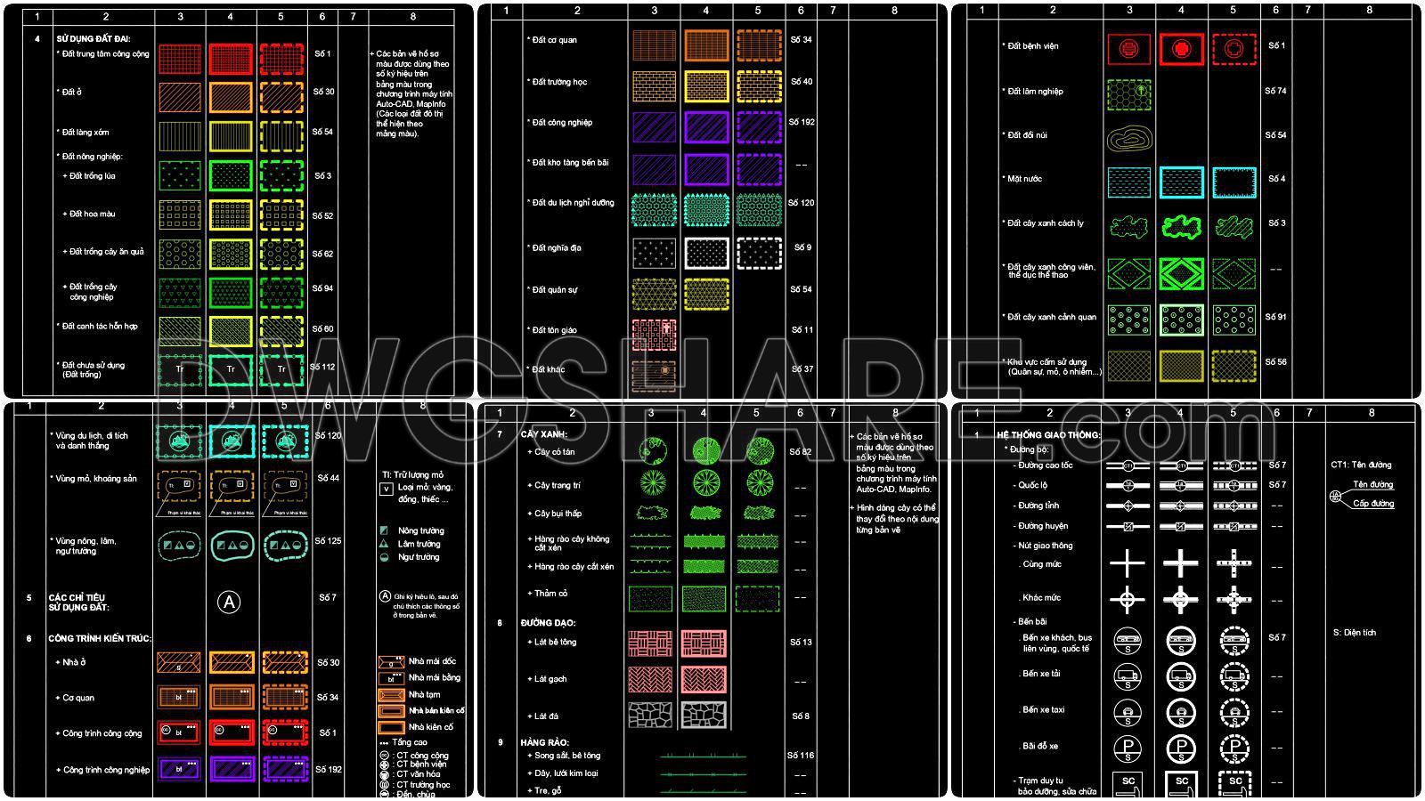
A large portion of the library focuses on land-use planning categories. Different land types are distinguished by colors and hatch patterns. Residential land, public land, industrial land, warehouse areas, and tourism land all have their own graphical patterns. There are also special land types such as cemeteries, religious land, military zones, or restricted construction areas. These diverse hatch patterns improve the readability and clarity of planning maps.
Green spaces and water bodies are also an essential part of planning drawings. The symbol library includes various tree symbols such as shade trees, decorative trees, street trees, and park vegetation patterns. Water elements like lakes, rivers, and reservoirs are also included. These elements help visualize the ecological and landscape structure of the urban environment.
Transportation infrastructure is presented in detail as well. The library includes symbols for expressways, national highways, provincial roads, district roads, and major intersections. Additional elements such as bus stations, parking areas, and transport facilities are also included. In most planning projects, transportation networks form the backbone of the urban structure, so clear representation is essential.
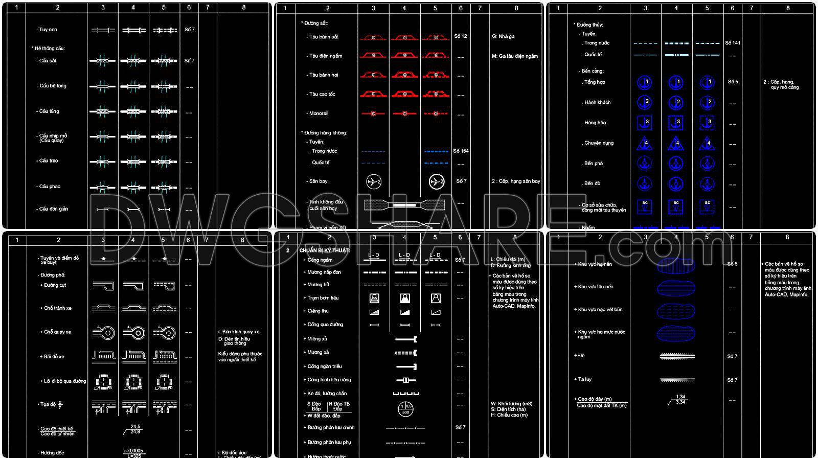
Beyond road systems, the library also includes symbols for railways, airports, and waterways. Railway lines, train stations, airports, and seaports are represented using standardized planning symbols. This allows designers to quickly incorporate them into planning drawings without recreating symbols manually.
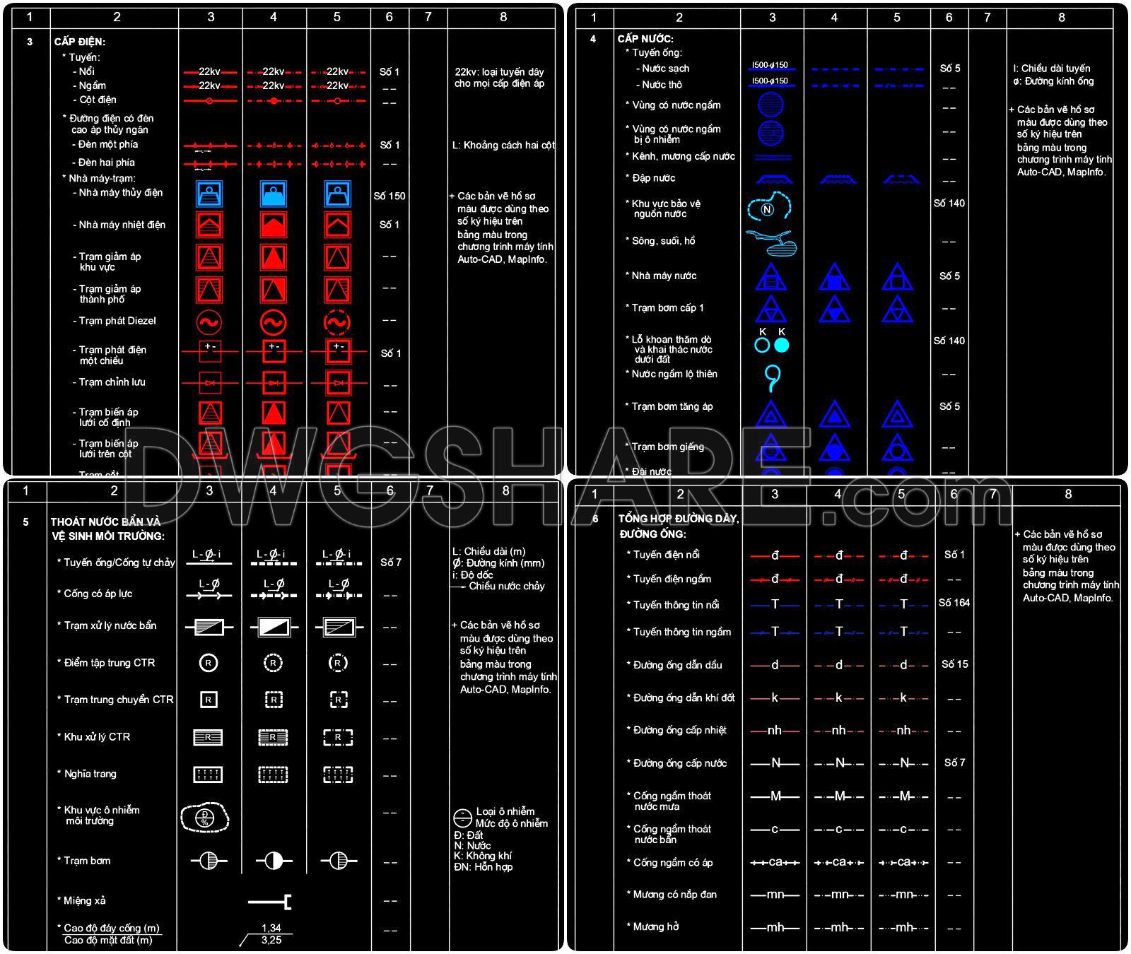
Another useful section focuses on urban technical infrastructure systems. These include electricity supply networks, water supply systems, drainage systems, and communication infrastructure. Power transmission lines, substations, water treatment plants, pumping stations, and drainage networks are represented using specialized symbols. These components are commonly used in technical infrastructure planning drawings.
Additionally, the library includes symbols related to terrain and engineering conditions such as embankments, dikes, slope protections, foundation areas, flood-prone zones, and special technical areas that require engineering solutions. These symbols are particularly useful in planning projects located in areas with complex terrain conditions.
Overall, this CAD drawing set functions like a “symbol dictionary” for urban planning maps. Using a standardized symbol system helps make drawings more professional and easier to understand. For architects, planners, and engineers who frequently work with AutoCAD in urban planning and infrastructure projects, a symbol library like this can significantly save time during the drafting process.
40. Free Download Complete CAD Urban Planning Symbols and Legend Blocks DWG
I also recommend downloading other Title Blocks Templates CAD drawings for your project reference.
- File format: .DWG
- Size: 0.9 MB
- Source: DWGshare
- AutoCAD platform 2018 and later versions. For downloading files there is no need to go through the registration process
Advertisements