

250 Maps of Cities Around the World File DWG or DXF
Advertisements
250 Maps of Cities Around the World File DWG or DXF
These are huge and simplified two-dimensional DXF files of metropolitan area road networks, which include 3 levels of roads as polylines, as well as bodies of water.
How to use these maps [DXF] [DWG] files?
Scale the files?
All model units are in Meters. Thus, you may need to select “Meters” as the unit when opening or importing a file.
The coordinate system?
- The model is located at the origin (0,0,0). In some programs, you may need to zoom out from the origin to view the entire model: a shortcut to do this in AutoCAD is by clicking [Top][Top] at the top left of the viewport to recenter the view.
- For large files greater than 100 MB, it may take some time for the model to be displayed.
The use a license for the data?
All files are distributed under the Open Database License, which permits commercial use. There are attribution requirements if you create something that is a Derivative Work of the source OpenStreetMap Database.
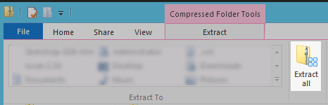
Zip Files
In most cases, you will need to Extract the CAD file from the .ZIP download. This is done via the button highlighted below in Windows Explorer.
Program Compatibility
Autodesk AutoCAD
In general, any program that opens AutoCAD .DWG files can also open. DXF files.
Confirmed to work on Mac and Windows on versions greater than 2012. If you are seeing this alert in AutoCAD:

Make sure you have unzipped it, and do not open the DXF by double-clicking in Explorer. Instead, first, start AutoCAD, and then use “Open” in the top left menu. Read more about this issue here and here.
Autodesk Inventor
See import instructions here.
Trimble SketchUp
Use the Native SKP format with either SketchUp professional or SketchUp Make (free). Each SKP file from Cadmapper is saved in version 2015, but all versions of SketchUp after 2015 should be able to open it.
Revit
Either the AutoCAD DXF format or the Rhino 3DM format should work well with Revit’s “Place Drawing…” operation.
McNeel Rhinoceros
Works great on version 5 and above for Mac and Windows. Building geometries are represented as solids instead of meshes, which is a significant advantage over DXF files. Cadmapper files with 3D elements, such as extruded buildings or terrain, will NOT open in Rhino 4. If you need to use Rhino 4, you will need to use a different program to first convert them to the Rhino .3DS file format.
Vectorworks
The Rhino 3DM format is recommended for its superior solids support.
Africa [Download Maps]
Asia [Download Maps]
Europe [Download Maps]
Middle East [Download Maps]
North America [Download Maps]
Oceania [Download Maps]
South America [Download Maps]
Source ww.cadmapper.com
Advertisements